Highway 11 Corridor Study
The Township of King has completed a Study focusing on the Highway 11 Corridor, a unique area located in the northeast part of the Township. The Corridor has historically functioned as a ‘highway commercial area’ consisting of land uses that can be characterized as commercial and tourism oriented. The Corridor is recognized as contributing to a vibrant rural economy and is located at juncture of key connections to neighbouring municipalities therefore having strategic locational significance as a gateway to the Township. The Study was completed in 3 phases to achieve the following objectives:
Main Objectives:
- Delineate the Study Area and geographic extent of the implementing land use planning framework;
- Develop an implementing land use planning framework that navigates applicable provincial plans and policy, while advancing Township and landowner interest in the desirable redevelopment of the Corridor that is representative of its strategic location and regional function; and
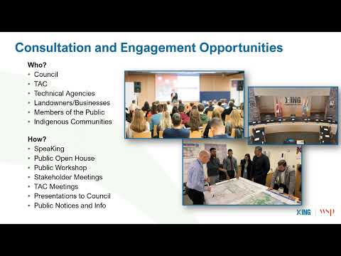
- Implement a process that focuses on consultation with the community, landowners, key stakeholders, agencies, and Council.
Project Phases:
- Phase 1: Draft Policy Discussion Paper and Study Area Delineation
- Phase 2: Public Consultation Opportunities
- Phase 3: Official Plan and Zoning By-law Amendments
Thank you for your Participation!
- The final proposed Official Plan Amendment and Zoning By-law Amendment were adopted by Council on March 17, 2025. The final Official Plan Amendment can be accessed here and Zoning By-law Amendment can be found here. The Zoning By-law Amendment is in force and effect, except as it applies to 20520 and 20550 Highway 11, which are subject to a site-specific appeal to the Ontario Land Tribunal.
If you have questions or require further information, please email policyplanning@king.ca.
Questions & Comments
Questions and comments on the Highway 11 Corridor Study can be submitted here, or emailed to the Project Team at policyplanning@king.ca. We look forward to receiving your thoughts and input!
Documents
-
 Final Adopted Amendments
-
 Highway 11 Corridor Study_Draft Official Plan Amendment_Final for Adoption (1.23 MB) (pdf)
-
Highway 11 Corridor Study_Final Draft Zoning By-law Amendment_February 6 2025_.pdf (1.57 MB) (pdf)
-
Highway 11 Corridor Study_Final Discussion Paper_Final for SPM-1.pdf (6.97 MB) (pdf)
-
Highway 11 Corridor Study_Draft Official Plan Amendment_Sept 13_FINAL.pdf (810 KB) (pdf)
-
Highway 11 Corridor Study Draft ZBLA _ Sept 13 FINAL.pdf (1.63 MB) (pdf)
-
Highway 11 Corridor Study_Notice.pdf (86.1 KB) (pdf)
-
Highway 11 Corridor - Notice of OH and PPM 2024_FINAL CIRC VERSION.docx dt.pdf (252 KB) (pdf)
-
Public Workshop Materials - January 30, 2024
-
Public Open House Notice - Nov 21 - final.pdf (126 KB) (pdf)
-
Township of King - Highway 11 Corridor Study Area Map.pdf (2.57 MB) (pdf)
-
King Township Hwy 11 Corridor_Draft Discussion Paper.pdf (4.64 MB) (pdf)


Thank you for your contribution!
Help us reach out to more people in the community
Share this with family and friends